Your say / Liveable Neighbourhoods
‘The same mistakes are being made ahead of the implementation of the South Bristol Liveable Neighbourhoods’
Few people would disagree with Bristol City Council’s stated aims for liveable neighbourhoods: making streets healthier, more accessible and more pleasant by putting people first, prioritising health, and making better community spaces.
They are laudable aims but they have been met with resistance.
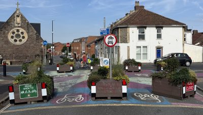
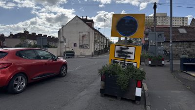
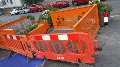
In east Bristol, following protests, the council’s contractors were eventually accompanied by police officers under cover of darkness to install the final planters, modal filters and bus gate; while in south Bristol, almost 3,000 people have now signed a ‘Stop Southville Roadblocks’ petition.
is needed now More than ever
What makes a place liveable varies with local context, although research suggests that it involves perceptions of community cohesion, safety and access to amenities.
But we need not get too bogged down in definitions of liveable because the schemes under discussion are actually low traffic neighbourhoods (LTNs), defined by the Department for Transport in 2024 as “an area-wide traffic management scheme aimed at reducing or removing through traffic from residential areas, put in place using traffic signed restrictions or physical measures such as planters or bollards”.
To avoid residents feeling misled, and imagining proposals for liveability that transport officers will not take forward, low traffic terminology should be used for schemes targeted at reducing through traffic.
Meanwhile, recent DfT guidance aims “to ensure that LTNs are only introduced where there is clear local support for them”.
And so we come to the critical issue of consultation. Both the leader of Bristol City Council and the deputy chief constable of Avon & Somerset Police expressed regret at the upset caused to residents of Lawrence Hill by the way in which some low traffic measures were introduced.
We were told that lessons had been learned and things would be done differently in south Bristol, which would include listening to initial feedback.
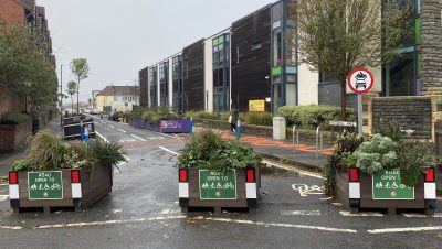
Between July and October 2024, residents provided more than 6,000 comments on an interactive map “to find out what issues and challenges their communities face” in the area under consideration for the South Bristol Liveable Neighbourhoods (SBLN).
The comments were analysed by council officers for an initial report that was shared with Arup, who are working with the council on designing the scheme, long before it was made available to residents.
Drafting the report, which was eventually made public in July 2025, could have been an opportunity to discuss issues and solutions with local people as part of a co-design process. But that did not happen.
It required a Freedom of Information request in October to access the SBLN initial engagement data.
Having examined almost 800 comments relating to my neighbourhood of Totterdown, I find it difficult to see a clear correlation between the issues raised and the proposals put forward for further consultation.
Some examples may help to illustrate the point.
My analysis suggests that around 145 comments related to Wells Road and 189 to St John’s Lane – highlighting congestion, inadequate pedestrian crossings, danger to cyclists, problems with traffic speed, noise and pollution – but no SBLN measures are proposed to address these issues.
Instead, the problems identified by the public may increase on both of these roads if a proposed bus gate on St Luke’s Road is implemented (of 114 comments relating to this road, five suggested closing it to motor traffic and 11 suggested making it one-way).
Neither could I understand why a convoluted one-way system was proposed for almost the entire Pylle Hill area when only five people had suggested making some (not all) of these streets one-way.
Numbers should not be the sole criteria used to design a scheme, but it would be helpful to know how and why the specific proposals were developed.
The opaque process has generated some mistrust over how data from the latest SBLN consultation survey will be used.
A recent freedom of information request for the raw data was refused by the council and the requester was told “the summary report will be published ahead of any future raw data release”.
So, once again, the analysis will take place and a report will be produced without the involvement of the people most affected – despite the council’s, albeit spasmodic, nod to ‘co-design’.
Consequently, there are concerns that the final design is a fait accompli.
To test local opinion, a short residents’ survey – asking if people agree, disagree, or don’t know about the nine proposals for Totterdown – was conducted alongside the council’s survey.
This showed clear opposition to five of the proposals (including the bus gate and the one-way system), more support than opposition for three proposals, and a balance for and against a residents’ parking scheme.
It will be interesting to see if these results match those in the council’s summary report and, when the raw data from the SBLN survey does become available, the extent to which local views really do shape the final proposals
This is an opinion piece by Suzanne Audrey, a resident of Totterdown whose main mode of transport is walking
Main photo: Martin Booth
Read next:
 Our newsletters emailed directly to you